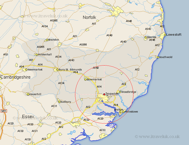
Suffolk Map Showing Location of Ipswich
Population: 128792
Area Size (ha): 3691
District: Ipswich
Easting: 616942 Northing: 247549
Latitude: 52.08 Longitude: 1.17
 = Ipswich
Area Size (ha): 3691
District: Ipswich
Easting: 616942 Northing: 247549
Latitude: 52.08 Longitude: 1.17
= Ipswich
This Ipswich map below is supplied by Google. Use the tools in the top left corner to zoom into street level or zoom out for a road map, you may also need to zoom in to see Ipswich on the map. Click and drag the map to move around. If the map fails to load try and refresh your browser or zoom in or out (+ or -).
Update - it seems Google no longer allow people to use their maps for free! This Ipswich map sometimes loads and sometimes gives a error. I am working on a solution.
Closest 30 Towns or Cities to Ipswich (Population over 500)
Witnesham 2.18km Wirnesham 2.18km Claydon 3.42km Henley 3.89km Bramford 4.92km Great Blakenham 4.92km Sproughton 5.87km Sprughton 5.87km Grundisburgh 5.99km Coddenham 6.52km Bucklesham 7.96km Martlesham Heath 8.18km Somersham 8.18km Nacton 8.7km Otley 8.7km Hintlesham 8.79km Martlesham 9.11km Woodbridge 10.41km Melton 10.41km Holbrook 11.12km Capel Saint Mary 11.51km Capel St. Mary 11.51km Capel St Mary 11.51km Capel 11.51km Chelmondiston 11.63km Bentley 12.5km Sutton 12.66km Stutton 13.01km Ufford 13.06km Great Bricett 13.06km