Dorset Map Showing Location of Bovington Camp
Population: 2294
Area Size (ha): 138
District: Purbeck
Easting: 382346 Northing: 89022
Latitude: 50.7 Longitude: -2.25
 = Bovington Camp
Area Size (ha): 138
District: Purbeck
Easting: 382346 Northing: 89022
Latitude: 50.7 Longitude: -2.25
= Bovington Camp
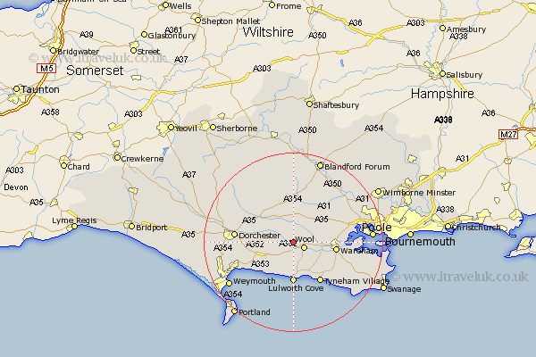
This Bovington Camp map below is supplied by Google. Use the tools in the top left corner to zoom into street level or zoom out for a road map, you may also need to zoom in to see Bovington Camp on the map. Click and drag the map to move around. If the map fails to load try and refresh your browser or zoom in or out (+ or -).
Update - it seems Google no longer allow people to use their maps for free! This Bovington Camp map sometimes loads and sometimes gives a error. I am working on a solution.
Closest 30 Towns or Cities to Bovington Camp (Population over 500)
Bovington Camp 0km Wool 2.78km Winfrith 5.68km Winfrith Newburgh 5.68km Bere Regis 6.03km Milborne 7.78km Milborne St Andrew 7.78km Milborne St. Andrew 7.78km Milborne Saint Andrew 7.78km Winterborne Kingston 8.21km Piddletown 8.97km Puddletown 8.97km Lulworth Cove 9.26km West Lulworth 9.26km Wareham 9.57km Broadmayne 9.57km Upton 10.01km Osmington 11.07km Whitechurch 11.18km Milton Abbas 11.36km Holton Heath Station 11.88km Holton Heath 11.88km Preston 12.99km Dorchester 13.04km Lytchett Matravers 14.05km Charminster 14.56km Overcombe 14.66km Winterborne Stickland 14.87km Stickland Winterborne 14.87km Piddletrenthide 14.94km