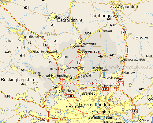
Hertfordshire Map Showing Location of Newgate Street
District: Broxbourne
Easting: 531239 Northing: 203756
Latitude: 51.72 Longitude: -0.1
 = Newgate Street
Easting: 531239 Northing: 203756
Latitude: 51.72 Longitude: -0.1
= Newgate Street
This Newgate Street map below is supplied by Google. Use the tools in the top left corner to zoom into street level or zoom out for a road map, you may also need to zoom in to see Newgate Street on the map. Click and drag the map to move around. If the map fails to load try and refresh your browser or zoom in or out (+ or -).
Update - it seems Google no longer allow people to use their maps for free! This Newgate Street map sometimes loads and sometimes gives a error. I am working on a solution.
Closest 30 Towns or Cities to Newgate Street (Population over 500)
Cuffley 2.18km Cheshunt 4.96km Essendon 5.06km Potters Bar 5.91km Brookmans Park 6.03km Bishops Hatfield 7.21km Hertingfordbury 7.41km Hoddesdon 7.82km Little Amwell 8.71km Great Amwell 9.37km Hertford 9.54km North Mymms 10.33km Ware 10.34km Hatfield 10.34km Colney Heath 10.49km Stanstead Abbots 10.92km Welwyn Garden City 11.54km Garden City 11.54km Tewin 11.64km Harmer Green 11.7km Shenley 12.07km London Colney 12.63km London Olney 12.63km Stapleford 12.97km Borehamwood 13.68km Thundridge 14.18km Widford 14.42km Watton at Stone 14.82km Watton 14.82km Sandridge 14.85km