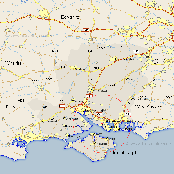
Hampshire Map Showing Location of Titchfield
District: Fareham
Easting: 455157 Northing: 104110
Latitude: 50.83 Longitude: -1.22
 = Titchfield
Easting: 455157 Northing: 104110
Latitude: 50.83 Longitude: -1.22
= Titchfield
This Titchfield map below is supplied by Google. Use the tools in the top left corner to zoom into street level or zoom out for a road map, you may also need to zoom in to see Titchfield on the map. Click and drag the map to move around. If the map fails to load try and refresh your browser or zoom in or out (+ or -).
Update - it seems Google no longer allow people to use their maps for free! This Titchfield map sometimes loads and sometimes gives a error. I am working on a solution.
Closest 30 Towns or Cities to Titchfield (Population over 500)
Fareham 2.99km Lee-on-Solent 3.89km Lee on Solent 3.89km Lee on the Solent 3.89km Lee-on-the-Solent 3.89km Locks Heath 6.79km Bursledon 6.93km Gosport 6.93km Portchester 7.02km Porchester 7.02km Hample 7.26km Hamble 7.26km Southwick 7.94km Wickham 8.2km Netley 8.99km Netley Marsh 8.99km Ashurst 9.02km Waltham Chase 9.34km Cowes 9.44km Fawley 9.55km Curbridge 9.56km Curdridge 9.56km Shidfield 9.56km Shedfield 9.56km Botley 9.91km East Cowes 10.96km Portsmouth 11.39km Gurnard 11.63km Swanmore 11.66km Ryde 11.66km