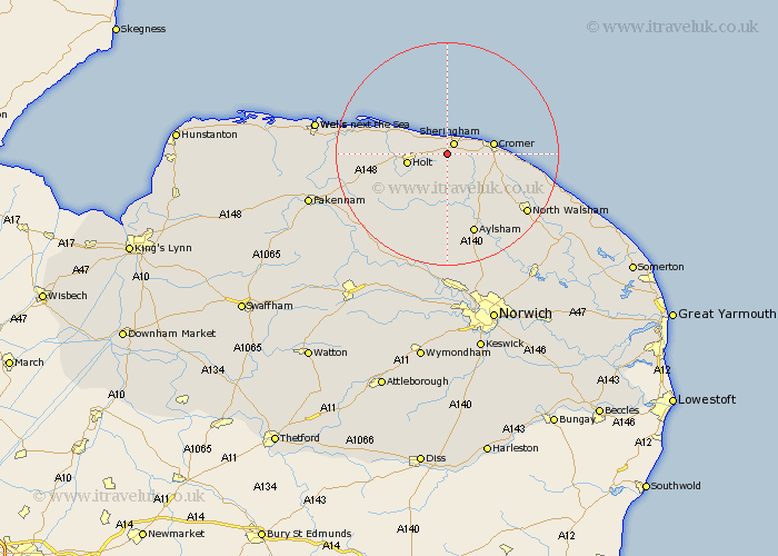
Norfolk Map Showing Location of West Beckham
Population: 222
District: North Norfolk
Easting: 613994 Northing: 340255
Latitude: 52.92 Longitude: 1.18
 = West Beckham
District: North Norfolk
Easting: 613994 Northing: 340255
Latitude: 52.92 Longitude: 1.18
= West Beckham
This West Beckham map below is supplied by Google. Use the tools in the top left corner to zoom into street level or zoom out for a road map, you may also need to zoom in to see West Beckham on the map. Click and drag the map to move around. If the map fails to load try and refresh your browser or zoom in or out (+ or -).
Update - it seems Google no longer allow people to use their maps for free! This West Beckham map sometimes loads and sometimes gives a error. I am working on a solution.
Closest 30 Towns or Cities to West Beckham (Population over 500)
Sheringham 2.16km Weybourne 2.9km West Runton 4.84km Runton 4.84km Holt 6.96km Cromer 8.04km Roughton 8.66km Northrepps 10.23km Erpingham 10.3km Briston 10.78km Overstrand 11.18km Corpusty 11.62km Mellon Constable 12.5km Melton Constable 12.5km Blakeney 13.48km Aylsham 15.49km Hindolveston 15.77km Trunch 16.32km Felmingham 16.43km Mundersley 16.61km Mundesley 16.61km Cawston 16.72km Marsham 17.27km North Walsham 17.43km Foulsham 18.58km Foulham 18.58km Reepham 19.07km Hevingham 19.36km Little Snoring 20.41km Bacton 20.41km