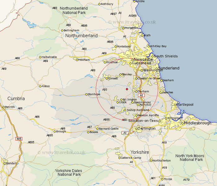
Durham Map Showing Location of Ushaw Moor
Population: 6056
Area Size (ha): 110
District: Durham
Easting: 422507 Northing: 543222
Latitude: 54.78 Longitude: -1.65
 = Ushaw Moor
Area Size (ha): 110
District: Durham
Easting: 422507 Northing: 543222
Latitude: 54.78 Longitude: -1.65
= Ushaw Moor
This Ushaw Moor map below is supplied by Google. Use the tools in the top left corner to zoom into street level or zoom out for a road map, you may also need to zoom in to see Ushaw Moor on the map. Click and drag the map to move around. If the map fails to load try and refresh your browser or zoom in or out (+ or -).
Update - it seems Google no longer allow people to use their maps for free! This Ushaw Moor map sometimes loads and sometimes gives a error. I am working on a solution.
Closest 30 Towns or Cities to Ushaw Moor (Population over 500)
Witton Gilbert 2.14km Langley Park 2.14km Esh 3.21km Brandon 4.28km Sacriston 4.28km Durham 5.65km Lanchester 6.51km Cornsay 7.48km Edmondsley 7.49km Shincliffe 7.71km Willington 8.07km Chester-le-Street 9.14km Annfield Plain 9.14km Pelton 9.81km Spennymoor 9.88km Bowburn 10.2km West Rainton 10.31km Crook 10.7km Stanley 10.73km Pittington 10.85km Sherburn 10.85km Ouston 12.03km Ouston Moor 12.03km Tow Law 12.05km Coxhoe 12.15km Birtley 12.33km Cornforth 12.61km West Cornforth 12.61km Ferryhill 12.84km Coundon 12.97km