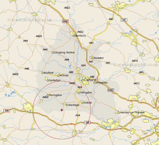
Oxfordshire Map Showing Location of Letcombe Bassett
Population: 170
District: Vale of White Horse
Easting: 438131 Northing: 183653
Latitude: 51.55 Longitude: -1.45
 = Letcombe Bassett
District: Vale of White Horse
Easting: 438131 Northing: 183653
Latitude: 51.55 Longitude: -1.45
= Letcombe Bassett
This Letcombe Bassett map below is supplied by Google. Use the tools in the top left corner to zoom into street level or zoom out for a road map, you may also need to zoom in to see Letcombe Bassett on the map. Click and drag the map to move around. If the map fails to load try and refresh your browser or zoom in or out (+ or -).
Update - it seems Google no longer allow people to use their maps for free! This Letcombe Bassett map sometimes loads and sometimes gives a error. I am working on a solution.
Closest 30 Towns or Cities to Letcombe Bassett (Population over 500)
Letcombe Regis 1.86km East Challow 3.7km Childrey 4.36km Wantage 5.06km Uffington 7.84km East Hanney 8.18km Hanney 8.18km Stanford in the Vale 9.89km Steventon 11.83km Chilton 12.68km Milton 12.74km Harwell 12.79km Kingston Bagpuze 13.18km Kingston Bagpuize 13.18km Buckland 13.43km Marcham 13.73km Watchfield 13.84km Drayton 13.9km Faringdon 14.44km Longworth 14.87km Didcot 14.9km Shrivenham 14.9km Blewbury 14.98km Hagbourne 15.43km East Hagbourne 15.43km Sutton Courtenay 15.69km Abingdon-on-Thames 17.34km Abingdon 17.34km Abingdon on Thames 17.34km Long Wittenham 17.6km