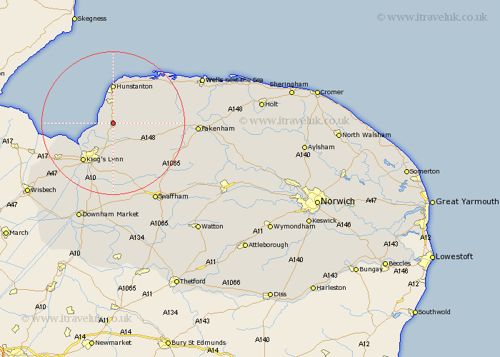
Norfolk Map Showing Location of Dersingham
Population: 3698
Area Size (ha): 130
District: King's Lynn and West Norfolk
Easting: 568326 Northing: 331019
Latitude: 52.85 Longitude: 0.5
 = Dersingham
Area Size (ha): 130
District: King's Lynn and West Norfolk
Easting: 568326 Northing: 331019
Latitude: 52.85 Longitude: 0.5
= Dersingham
This Dersingham map below is supplied by Google. Use the tools in the top left corner to zoom into street level or zoom out for a road map, you may also need to zoom in to see Dersingham on the map. Click and drag the map to move around. If the map fails to load try and refresh your browser or zoom in or out (+ or -).
Update - it seems Google no longer allow people to use their maps for free! This Dersingham map sometimes loads and sometimes gives a error. I am working on a solution.
Closest 30 Towns or Cities to Dersingham (Population over 500)
Dersingham 0km Snettisham 1.86km Ingoldisthorpe 2.17km Ingoldesthorpe 2.17km Sedgeford 6.49km Heacham 7.5km North Wootton 8.66km Great Bircham 8.95km Bircham 8.95km Docking 9.6km Grimston 9.85km South Wootton 10.29km Hunstanton 11.12km East Winch 12.98km Gayton 13.4km Lynn 13.61km Lynn Regis 13.61km Kings Lynn 13.61km King's Lynn 13.61km Massingham 14.54km Great Massingham 14.54km Syderstone 14.55km Middleton 14.99km Clenchwarton 15.01km East Rudham 15.02km Tattersett 15.78km Tatterset 15.78km Brancaster 16.42km North Runcton 17.27km Terrington St. Clement 17.45km