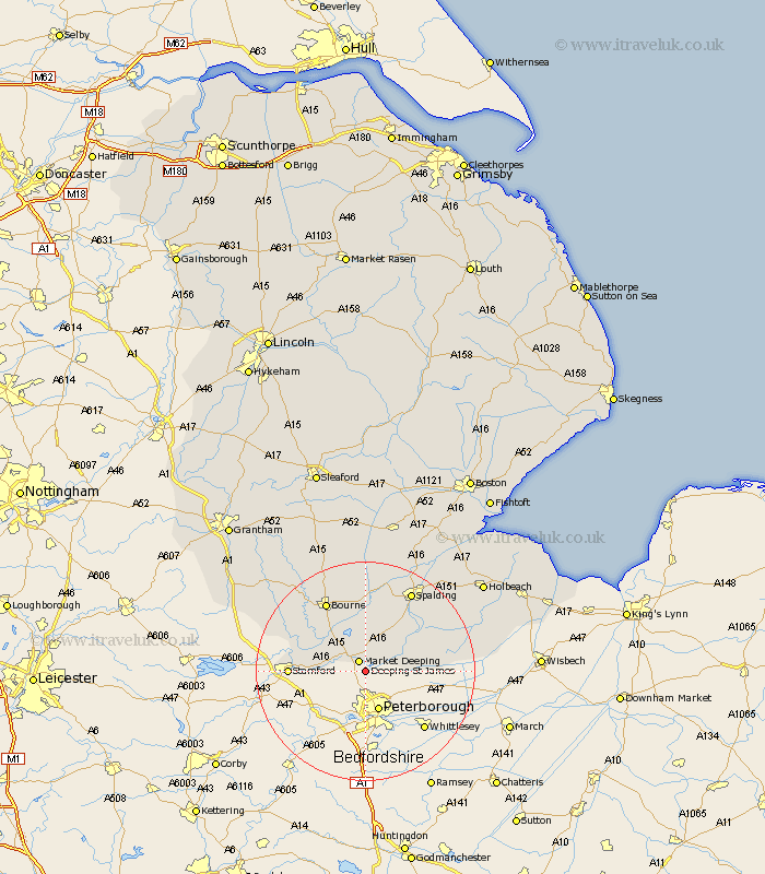
Lincolnshire Map Showing Location of Deeping Saint James
Population: 6923
District: South Kesteven
Easting: 516119 Northing: 307229
Latitude: 52.65 Longitude: -0.28
 = Deeping Saint James
District: South Kesteven
Easting: 516119 Northing: 307229
Latitude: 52.65 Longitude: -0.28
= Deeping Saint James
This Deeping Saint James map below is supplied by Google. Use the tools in the top left corner to zoom into street level or zoom out for a road map, you may also need to zoom in to see Deeping Saint James on the map. Click and drag the map to move around. If the map fails to load try and refresh your browser or zoom in or out (+ or -).
Update - it seems Google no longer allow people to use their maps for free! This Deeping Saint James map sometimes loads and sometimes gives a error. I am working on a solution.
Closest 30 Towns or Cities to Deeping Saint James (Population over 500)
Market Deeping 2.17km Langfoft 6.5km Langtoft 6.5km Baston 7.15km Uffington 8.99km Croyland 9.18km Crowland 9.18km Thurlby 9.3km Deeping St Nicholas 9.3km Deeping St. Nicholas 9.3km Deeping Saint Nicholas 9.3km Leverington 10.29km Stamford 13.49km Cowbit 14.56km Bourn 14.62km Bourne 14.62km Morton 15.85km Spalding 16.78km Gedney Hill 18.08km Godney Hill 18.08km Pinchbeck 18.94km Castle Bytham 19.23km Rippingale 19.37km Moulton 21.6km Weston 22.16km Whaplode 22.43km Pointon 22.49km Surfleet 22.75km Corby 22.92km Gosberton 23.98km