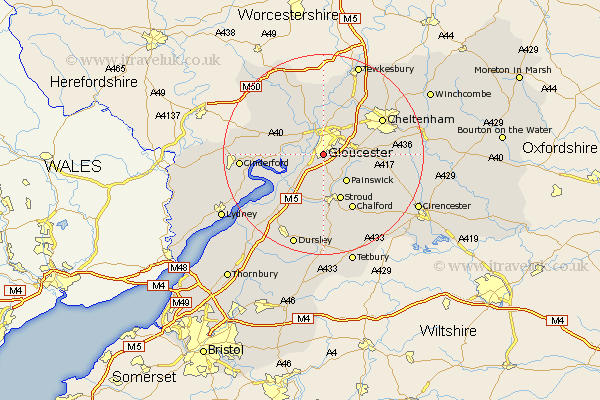
Gloucestershire Map Showing Location of Gloucester
Population: 112268
Area Size (ha): 3040
District: Gloucester
Easting: 382775 Northing: 215044
Latitude: 51.83 Longitude: -2.25
 = Gloucester
Area Size (ha): 3040
District: Gloucester
Easting: 382775 Northing: 215044
Latitude: 51.83 Longitude: -2.25
= Gloucester
This Gloucester map below is supplied by Google. Use the tools in the top left corner to zoom into street level or zoom out for a road map, you may also need to zoom in to see Gloucester on the map. Click and drag the map to move around. If the map fails to load try and refresh your browser or zoom in or out (+ or -).
Update - it seems Google no longer allow people to use their maps for free! This Gloucester map sometimes loads and sometimes gives a error. I am working on a solution.
Closest 30 Towns or Cities to Gloucester (Population over 500)
Quedgeley 2.94km Hardwicke 3.9km Hucclecote 4.94km Brockworth 6.02km Innsworth 6.53km Painswick 7.21km Randwick 7.41km Churchdown 7.98km Stonehouse 9.54km Stroud 9.88km Shurdington 9.88km Hartpury 9.89km Tibberton 10.11km Staverton 10.9km Frampton-on-Severn 10.92km Frampton 10.92km Frampton on Severn 10.92km Huntley 10.95km Ashleworth 11.18km Corse 11.64km Leckhampton 12.03km Chalford 12.51km Woodchester 13.02km Charlton Kings 13.13km Newham 13.13km Newnham 13.13km Cheltenham 13.64km Coaley 14.18km Longhope 14.23km Awre 14.62km