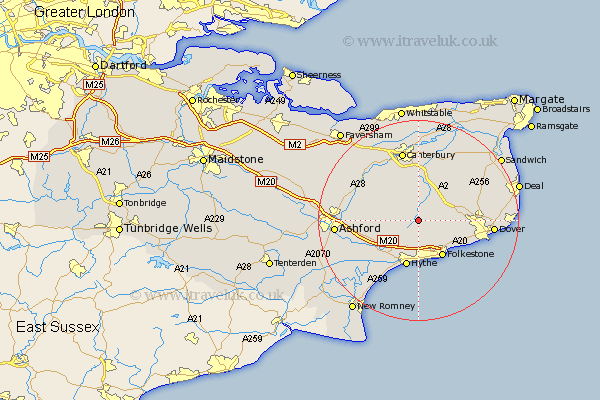
Kent Map Showing Location of Elham
Population: 1354
Area Size (ha): 30
District: Shepway
Easting: 617945 Northing: 143647
Latitude: 51.15 Longitude: 1.12
 = Elham
Area Size (ha): 30
District: Shepway
Easting: 617945 Northing: 143647
Latitude: 51.15 Longitude: 1.12
= Elham
This Elham map below is supplied by Google. Use the tools in the top left corner to zoom into street level or zoom out for a road map, you may also need to zoom in to see Elham on the map. Click and drag the map to move around. If the map fails to load try and refresh your browser or zoom in or out (+ or -).
Update - it seems Google no longer allow people to use their maps for free! This Elham map sometimes loads and sometimes gives a error. I am working on a solution.
Closest 30 Towns or Cities to Elham (Population over 500)
Lyminge 4.37km Swingfield 5.01km Stelling 5.09km Hawkinge 6.56km Alkham 8.35km Brabourne 8.35km Petham 8.75km Folkestone 8.76km Folkstone 8.76km Sibertswold 8.94km Shepherdswell 8.94km Bridge 9.26km Lydden 9.3km Coldred 9.48km Hythe 9.55km Sellinge 9.86km Sellindge 9.86km Lower Hardres 9.9km Ewell 10.46km Temple Ewell 10.46km River 10.63km Lympne 10.94km Smeeth 11.1km Eythorne 12.2km Hinxhill 12.92km Chartham 13.12km Wye 13.31km Littlebourne 13.44km Aldington 13.8km Mersham 13.95km