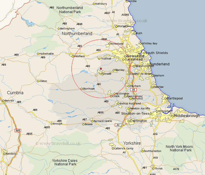
Durham Map Showing Location of Ebchester
District: Derwentside
Easting: 410691 Northing: 554305
Latitude: 54.88 Longitude: -1.83
 = Ebchester
Easting: 410691 Northing: 554305
Latitude: 54.88 Longitude: -1.83
= Ebchester
This Ebchester map below is supplied by Google. Use the tools in the top left corner to zoom into street level or zoom out for a road map, you may also need to zoom in to see Ebchester on the map. Click and drag the map to move around. If the map fails to load try and refresh your browser or zoom in or out (+ or -).
Update - it seems Google no longer allow people to use their maps for free! This Ebchester map sometimes loads and sometimes gives a error. I am working on a solution.
Closest 30 Towns or Cities to Ebchester (Population over 500)
Leadgate 2.82km Consetti 3.7km Consett 3.7km Castleside 5.96km Annfield Plain 7.39km Rowlands Gill 7.39km Burnopfield 7.69km Stanley 8.01km Lanchester 9.79km Whickham 11.08km Cornsay 11.91km Blaydon 12.59km Edmondsley 13.32km Esh 14.02km Langley Park 14.13km Ouston Moor 14.28km Ouston 14.28km Pelton 15.04km Lamesley 15.37km Gateshead 15.41km Gateshead on Tyne 15.41km Gateshead-on-Tyne 15.41km Sacriston 15.72km Witton Gilbert 15.81km Ushaw Moor 16.17km Tow Law 16.71km Birtley 17.06km Chester-le-Street 17.46km Wolsingham 18.8km Stanhope 18.91km