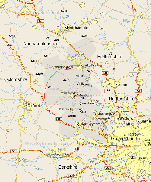
Buckinghamshire Map Showing Location of Aylesbury
Population: 57122
Area Size (ha): 1424
District: Aylesbury Vale
Easting: 482707 Northing: 213849
Latitude: 51.82 Longitude: -0.8
 = Aylesbury
Area Size (ha): 1424
District: Aylesbury Vale
Easting: 482707 Northing: 213849
Latitude: 51.82 Longitude: -0.8
= Aylesbury
This Aylesbury map below is supplied by Google. Use the tools in the top left corner to zoom into street level or zoom out for a road map, you may also need to zoom in to see Aylesbury on the map. Click and drag the map to move around. If the map fails to load try and refresh your browser or zoom in or out (+ or -).
Update - it seems Google no longer allow people to use their maps for free! This Aylesbury map sometimes loads and sometimes gives a error. I am working on a solution.
Closest 30 Towns or Cities to Aylesbury (Population over 500)
Aylesbury 0km Stoke Mandeville 3.89km Stone 3.91km Weston Turville 5.06km Halton 5.9km Aston Clinton 6.02km Buckland 6.02km Wendover 6.54km Ellesborough 7.5km Whitchurch 7.75km Whitechurch 7.75km Waddesdon 8.23km North Marston 8.71km Cuddington 8.84km Marsworth 9.16km Kimble 9.27km Great Kimble 9.27km Cheddington 9.35km Wing 9.36km Quainton 9.75km Haddenham 9.76km Longwick 9.89km Princes Risborough 11.18km Stewkley 11.64km Chearsley 11.72km Bledlow 12.03km Pitstone 12.6km Slapton 12.73km Ivinghoe 12.73km Mursley 13.02km