Berkshire Map Showing Location of Easthampstead
Easting: 486977 Northing: 165713
Latitude: 51.38 Longitude: -0.75
 = Easthampstead
Latitude: 51.38 Longitude: -0.75
= Easthampstead
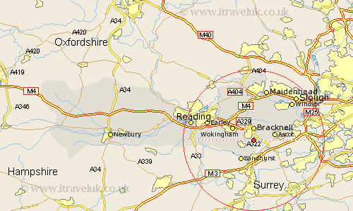
This Easthampstead map below is supplied by Google. Use the tools in the top left corner to zoom into street level or zoom out for a road map, you may also need to zoom in to see Easthampstead on the map. Click and drag the map to move around. If the map fails to load try and refresh your browser or zoom in or out (+ or -).
Update - it seems Google no longer allow people to use their maps for free! This Easthampstead map sometimes loads and sometimes gives a error. I am working on a solution.
Closest 30 Towns or Cities to Easthampstead (Population over 500)
Bracknell 3.71km Warfield 3.89km Crowthorne 4.98km Binfield 6.03km Ascot 6.07km Sandhurst 6.55km Winkfield 6.55km Wokingham 6.87km Sunninghill 6.94km Finchampstead 7.87km Winnersh 8.9km Barkham 9.25km Sunningdale 9.25km Waltham St. Lawrence 9.9km Waltham St Lawrence 9.9km Waltham Saint Lawrence 9.9km White Waltham 11.18km Twyford 11.58km Aberfield 11.71km Arborfield 11.71km Woodley 11.85km Bray 13.43km Old Windsor 13.73km Horton 13.73km Wagrave 13.75km Wargrave 13.75km Earley 13.88km Sonning 13.93km Frogmore House 13.93km Frogmore 13.93km