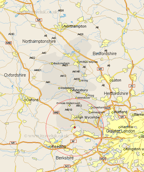
Buckinghamshire Map Showing Location of Marlow
Population: 17281
Area Size (ha): 486
District: Wycombe
Easting: 485474 Northing: 186087
Latitude: 51.57 Longitude: -0.77
 = Marlow
Area Size (ha): 486
District: Wycombe
Easting: 485474 Northing: 186087
Latitude: 51.57 Longitude: -0.77
= Marlow
This Marlow map below is supplied by Google. Use the tools in the top left corner to zoom into street level or zoom out for a road map, you may also need to zoom in to see Marlow on the map. Click and drag the map to move around. If the map fails to load try and refresh your browser or zoom in or out (+ or -).
Update - it seems Google no longer allow people to use their maps for free! This Marlow map sometimes loads and sometimes gives a error. I am working on a solution.
Closest 30 Towns or Cities to Marlow (Population over 500)
Little Marlow 2.95km Bourne End 4.61km Wooburn 5.76km Flackwell Heath 5.91km Medmenham 6.05km Hambleden 6.91km Wycombe 7.41km Chepping 7.41km High Wycombe 7.41km West Wycombe 7.76km Penn 8km Taplow 8.01km Lane End 8.86km Hughenden 9.54km Bradenham 9.54km Burnham 9.8km Beaconsfield 9.93km Hazlemere 10.34km Dorney 10.96km Farnham Royal 11.02km Hedgerley 11.52km Stokenchurch 13.06km Little Missenden 13.09km Radnage 14.69km Chalfont Saint Giles 14.89km Chalfont St. Giles 14.89km Chalfont St Giles 14.89km Prestwood 15km Gerrards Cross 15km Fulmer 15.09km