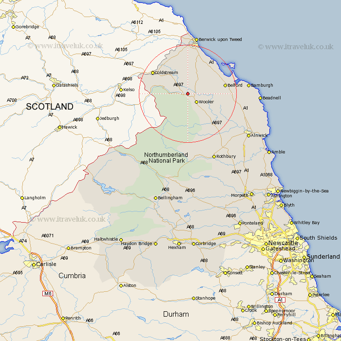
Northumberland Map Showing Location of Ewart
Population: 72
District: Berwick-upon-Tweed
Easting: 396847 Northing: 630337
Latitude: 55.57 Longitude: -2.05
 = Ewart
District: Berwick-upon-Tweed
Easting: 396847 Northing: 630337
Latitude: 55.57 Longitude: -2.05
= Ewart
This Ewart map below is supplied by Google. Use the tools in the top left corner to zoom into street level or zoom out for a road map, you may also need to zoom in to see Ewart on the map. Click and drag the map to move around. If the map fails to load try and refresh your browser or zoom in or out (+ or -).
Update - it seems Google no longer allow people to use their maps for free! This Ewart map sometimes loads and sometimes gives a error. I am working on a solution.
Closest 30 Towns or Cities to Ewart (Population over 500)
Wooler 4.86km Lowick 9.07km Belford 14.11km Ancroft 15.15km Norham 17.82km East Ord 20.49km Ord 20.49km North Sunderland 24.1km Berwick-upon-Tweed 24.29km Berwick upon Tweed 24.29km Berwick on Tweed 24.29km Berwick-Upon-Tweed 24.29km Berwick-on-Tweed 24.29km Berwick 24.29km Beadnell 26.27km Alnwick 28.81km Almwick 28.81km Embleton 28.81km Rothbury 29.36km Shilbottle 32.07km Alnmouth 33.87km Lesbury 34.08km Lisburg 34.08km Longframlington 35.72km Swarland 35.76km Warkworth 36.43km Felton 38.48km Thirston 39.09km East Thirston 39.09km Amble 39.24km