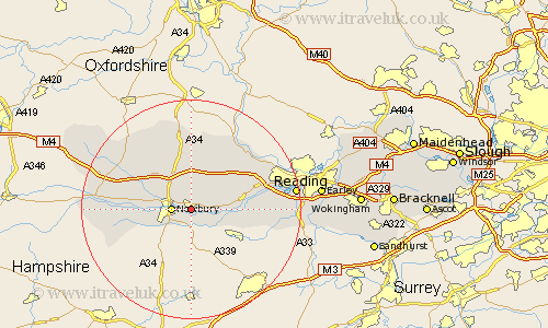
Berkshire Map Showing Location of Thatcham
Population: 20344
Area Size (ha): 474
Easting: 451008 Northing: 167084
Latitude: 51.4 Longitude: -1.27
 = Thatcham
Area Size (ha): 474
Easting: 451008 Northing: 167084
Latitude: 51.4 Longitude: -1.27
= Thatcham
This Thatcham map below is supplied by Google. Use the tools in the top left corner to zoom into street level or zoom out for a road map, you may also need to zoom in to see Thatcham on the map. Click and drag the map to move around. If the map fails to load try and refresh your browser or zoom in or out (+ or -).
Update - it seems Google no longer allow people to use their maps for free! This Thatcham map sometimes loads and sometimes gives a error. I am working on a solution.
Closest 30 Towns or Cities to Thatcham (Population over 500)
Cold Ash 2.19km Greenham 2.19km Shaw 2.31km Newbury 3.47km Hermitage 5.56km Speen 5.78km Bucklebury 5.92km Chieveley 6.55km Brimpton 6.87km Beenham 8.3km Aldermaston 8.31km Bradfield 9.96km Welford 10.79km Kintbury 11.71km Compton 13.03km Theale 14.35km Shefford 14.71km Great Shefford 14.71km West Shefford 14.71km East Ilsley 14.87km Basildon 15.22km Streatley 15.29km Inkpen 15.48km Pangbourne 15.72km Burghfield 16.19km Tilehurst 17.11km Hungerford 17.44km East Garston 17.64km Stratfield Mortimer 17.74km Mortimer 17.74km