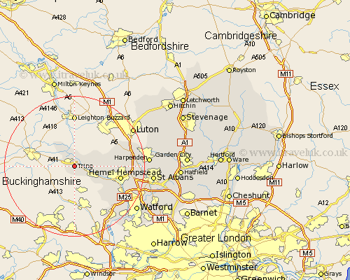
Hertfordshire Map Showing Location of Tring
Population: 11402
Area Size (ha): 270
District: Dacorum
Easting: 493114 Northing: 210316
Latitude: 51.78 Longitude: -0.65
 = Tring
Area Size (ha): 270
District: Dacorum
Easting: 493114 Northing: 210316
Latitude: 51.78 Longitude: -0.65
= Tring
This Tring map below is supplied by Google. Use the tools in the top left corner to zoom into street level or zoom out for a road map, you may also need to zoom in to see Tring on the map. Click and drag the map to move around. If the map fails to load try and refresh your browser or zoom in or out (+ or -).
Update - it seems Google no longer allow people to use their maps for free! This Tring map sometimes loads and sometimes gives a error. I am working on a solution.
Closest 30 Towns or Cities to Tring (Population over 500)
Wigginton 2.17km Aldbury 3.91km Northchurch 4.94km Little Gaddesden 7.12km Berkhampstead 7.81km Berkhamsted 7.81km Great Gaddesden 10.32km Bovingdon 10.92km Hemel Hempstead 13.15km Chipperfield 14.75km Markyate 14.83km Markyatestreet 14.83km Flamstead 15.35km Sarratt 15.98km Kings Langley 16.6km Redbourn 18.34km Abbots Langley 18.54km Chorleywood 18.75km Harpenden 20.72km Rickmansworth 20.92km Watford 21.55km Croxley Green 21.64km Saint Albans 22.1km St. Albans 22.1km St Albans 22.1km Sandridge 24.15km Aldenham 24.39km Wheathampstead 25.29km Radlett 25.51km Kimpton 26.27km