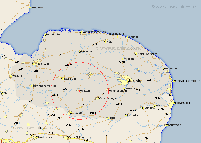
Norfolk Map Showing Location of Watton
Population: 5886
Area Size (ha): 256
District: Breckland
Easting: 592005 Northing: 300352
Latitude: 52.57 Longitude: 0.83
 = Watton
Area Size (ha): 256
District: Breckland
Easting: 592005 Northing: 300352
Latitude: 52.57 Longitude: 0.83
= Watton
This Watton map below is supplied by Google. Use the tools in the top left corner to zoom into street level or zoom out for a road map, you may also need to zoom in to see Watton on the map. Click and drag the map to move around. If the map fails to load try and refresh your browser or zoom in or out (+ or -).
Update - it seems Google no longer allow people to use their maps for free! This Watton map sometimes loads and sometimes gives a error. I am working on a solution.
Closest 30 Towns or Cities to Watton (Population over 500)
Griston 2.92km Carbrooke 3.85km Carbooke 3.85km Ashill 4.33km Rockland St Peter 6.75km Rockland Saint Peter 6.75km Rockland 6.75km Rockland St. Peter 6.75km Shipdham 7.15km Hockham 8.15km Great Ellingham 9.75km Necton 9.86km Hingham 10.3km Yaxham 12.92km Palgrave 13.01km Great Palgrave 13.01km Attleborough 13.59km Mundford 14.45km Swaffham 14.58km Dereham 14.62km East Dereham 14.62km Besthorpe 14.62km Northwold 15.88km East Harling 16.3km Mattishall 16.38km Quidenham 16.48km Litcham 16.83km Harling 17.28km Old Buckenham 17.35km Beetley 17.6km