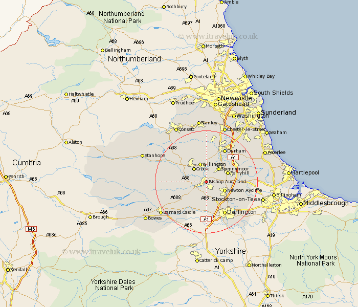
Durham Map Showing Location of Bishop Auckland
Population: 23139
Area Size (ha): 641
District: Wear Valley
Easting: 421505 Northing: 528385
Latitude: 54.65 Longitude: -1.67
 = Bishop Auckland
Area Size (ha): 641
District: Wear Valley
Easting: 421505 Northing: 528385
Latitude: 54.65 Longitude: -1.67
= Bishop Auckland
This Bishop Auckland map below is supplied by Google. Use the tools in the top left corner to zoom into street level or zoom out for a road map, you may also need to zoom in to see Bishop Auckland on the map. Click and drag the map to move around. If the map fails to load try and refresh your browser or zoom in or out (+ or -).
Update - it seems Google no longer allow people to use their maps for free! This Bishop Auckland map sometimes loads and sometimes gives a error. I am working on a solution.
Closest 30 Towns or Cities to Bishop Auckland (Population over 500)
Coundon 2.14km Shildon 2.14km West Auckland 4.67km Etherley 5.36km High Etherley 5.36km Spennymoor 6.96km Crook 7.02km Evenwood 7.42km Newton Aycliffe 7.43km Willington 7.72km Ferryhill 8.37km Cockfield 9.35km Cornforth 11.13km West Cornforth 11.13km Brandon 11.57km Gainford 11.92km Bishop Middleham 12.36km Staindrop 12.63km Coxhoe 13.03km Tow Law 13.37km Bowburn 13.37km Durham 14.48km Darlington 14.49km Ushaw Moor 14.86km Esh 14.98km Sedgefield 15.01km Fishburn 15.46km Shincliffe 15.55km Wolsingham 15.78km Stillington 16.02km