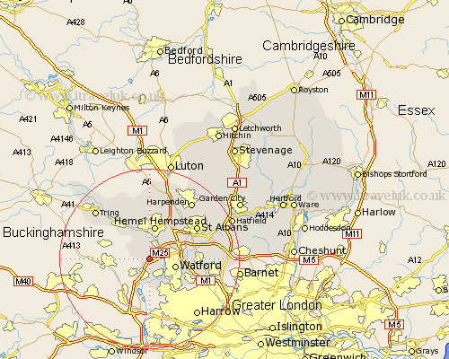
Hertfordshire Map Showing Location of Sarratt
Population: 1883
District: Three Rivers
Easting: 504840 Northing: 199422
Latitude: 51.68 Longitude: -0.48
 = Sarratt
District: Three Rivers
Easting: 504840 Northing: 199422
Latitude: 51.68 Longitude: -0.48
= Sarratt
This Sarratt map below is supplied by Google. Use the tools in the top left corner to zoom into street level or zoom out for a road map, you may also need to zoom in to see Sarratt on the map. Click and drag the map to move around. If the map fails to load try and refresh your browser or zoom in or out (+ or -).
Update - it seems Google no longer allow people to use their maps for free! This Sarratt map sometimes loads and sometimes gives a error. I am working on a solution.
Closest 30 Towns or Cities to Sarratt (Population over 500)
Chipperfield 1.86km Kings Langley 2.95km Chorleywood 3.7km Abbots Langley 4.96km Bovingdon 5.07km Rickmansworth 5.68km Croxley Green 6.02km Watford 6.03km Hemel Hempstead 7.51km Berkhampstead 8.72km Berkhamsted 8.72km Aldenham 9.38km Bushey 10.74km Great Gaddesden 11.18km Radlett 11.49km Northchurch 11.55km Saint Albans 12.72km St. Albans 12.72km St Albans 12.72km Redbourn 13.08km Little Gaddesden 13.76km Wigginton 13.88km London Colney 14.28km London Olney 14.28km Elstree 14.87km Shenley 14.94km Flamstead 15.23km Aldbury 15.26km Borehamwood 15.39km Sandridge 15.67km