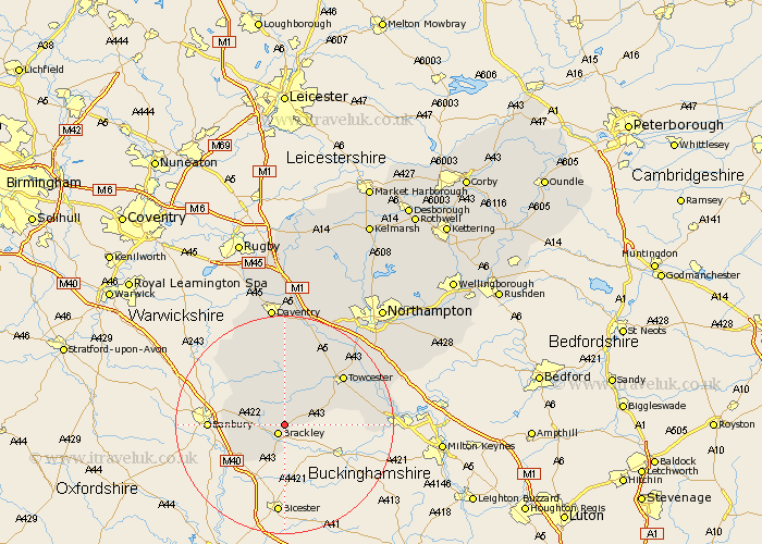
Northamptonshire Map Showing Location of Radstone
Population: 54
District: South Northamptonshire
Easting: 459424 Northing: 239468
Latitude: 52.05 Longitude: -1.13
 = Radstone
District: South Northamptonshire
Easting: 459424 Northing: 239468
Latitude: 52.05 Longitude: -1.13
= Radstone
This Radstone map below is supplied by Google. Use the tools in the top left corner to zoom into street level or zoom out for a road map, you may also need to zoom in to see Radstone on the map. Click and drag the map to move around. If the map fails to load try and refresh your browser or zoom in or out (+ or -).
Update - it seems Google no longer allow people to use their maps for free! This Radstone map sometimes loads and sometimes gives a error. I am working on a solution.
Closest 30 Towns or Cities to Radstone (Population over 500)
Brackley 2.18km Helmdon 3.7km Greatworth 3.89km Syresham 3.89km Croughton 8.71km Silverstone 8.79km Kings Sutton 9.84km Aynho 10.9km Chalcombe 10.9km Chacombe 10.9km Whittlebury 10.9km Chipping Warden 11.75km Towcester 13.81km Paulerspury 14.16km Byfield 14.66km Pattishall 15.23km Boddington 16.53km Upper Boddington 16.53km Potterspury 17.19km Gayton 17.26km Bugbrooke 18.48km Blisworth 18.84km Badby 18.85km Weedon 19.09km Weedon Beck 19.09km Deanshanger 19.38km Denshanger 19.38km Roade 20.38km Milton 20.94km Flore 21.17km