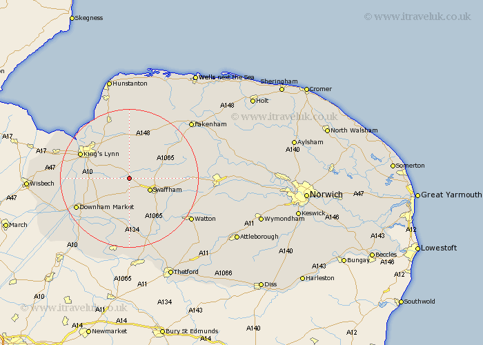
Norfolk Map Showing Location of Narborough
Population: 1095
District: Breckland
Easting: 574601 Northing: 312681
Latitude: 52.68 Longitude: 0.58
 = Narborough
District: Breckland
Easting: 574601 Northing: 312681
Latitude: 52.68 Longitude: 0.58
= Narborough
This Narborough map below is supplied by Google. Use the tools in the top left corner to zoom into street level or zoom out for a road map, you may also need to zoom in to see Narborough on the map. Click and drag the map to move around. If the map fails to load try and refresh your browser or zoom in or out (+ or -).
Update - it seems Google no longer allow people to use their maps for free! This Narborough map sometimes loads and sometimes gives a error. I am working on a solution.
Closest 30 Towns or Cities to Narborough (Population over 500)
Marham 4.33km Gayton 6km Swaffham 6.73km Castle Acre 6.99km Shouldham 7.69km East Winch 7.9km Middleton 8.69km Grimston 9.54km North Runcton 10.28km Palgrave 10.28km Great Palgrave 10.28km Massingham 10.84km Great Massingham 10.84km Runcton 12.91km Runcton Holme 12.91km Wereham 13.01km Watlington 13.61km South Wootton 13.71km Stoke Ferry 13.72km Necton 13.99km Northwold 14.87km North Wootton 15.02km Litcham 15.06km King's Lynn 15.38km Kings Lynn 15.38km Lynn Regis 15.38km Lynn 15.38km Downham Market 17.31km Ashill 17.31km East Rudham 17.34km