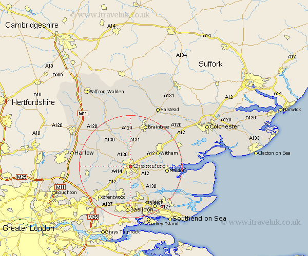
Essex Map Showing Location of Chelmsford
Population: 96421
Area Size (ha): 2367
District: Chelmsford
Easting: 571464 Northing: 206812
Latitude: 51.73 Longitude: 0.48
 = Chelmsford
Area Size (ha): 2367
District: Chelmsford
Easting: 571464 Northing: 206812
Latitude: 51.73 Longitude: 0.48
= Chelmsford
This Chelmsford map below is supplied by Google. Use the tools in the top left corner to zoom into street level or zoom out for a road map, you may also need to zoom in to see Chelmsford on the map. Click and drag the map to move around. If the map fails to load try and refresh your browser or zoom in or out (+ or -).
Update - it seems Google no longer allow people to use their maps for free! This Chelmsford map sometimes loads and sometimes gives a error. I am working on a solution.
Closest 30 Towns or Cities to Chelmsford (Population over 500)
Great Baddow 3.88km Galleywood 3.88km Broomfield 3.89km Writtle 3.91km Little Baddow 5.74km Boreham 5.9km Great Waltham 6.01km Danbury 6.83km Roxwell 7.13km Margaretting 7.21km Little Waltham 7.42km East Hanningfield 8.71km Terling 8.72km Bickacre 8.85km Bicknacre 8.85km West Hanningfield 9.33km Great Leighs 9.55km Hatfield Peverel 9.77km Stock 9.88km Ingatestone 10.12km Rettendon 10.34km Woodham Mortimer 10.98km South Hanningfield 11.36km Witham 11.73km High Easter 11.8km Woodham Ferrers 12.27km Ramsden Heath 13.17km Purleigh 13.67km Billericay 13.76km Black Notley 13.76km