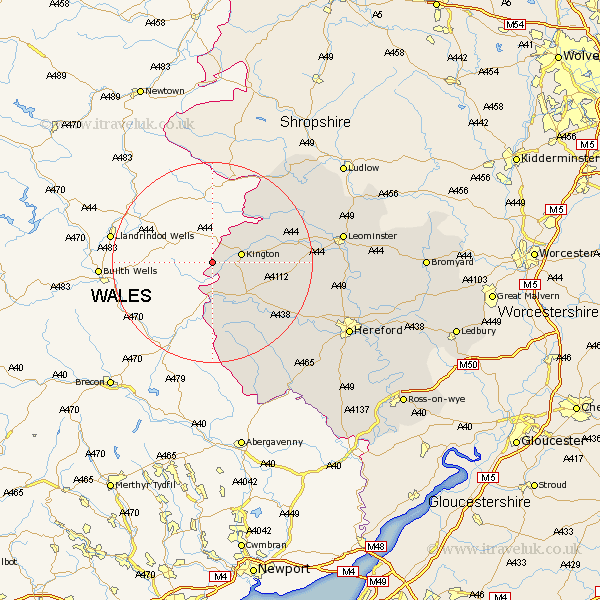
Herefordshire Map Showing Location of Huntington
Population: 107
Easting: 324801 Northing: 254509
Latitude: 52.18 Longitude: -3.1
 = Huntington
Easting: 324801 Northing: 254509
Latitude: 52.18 Longitude: -3.1
= Huntington
This Huntington map below is supplied by Google. Use the tools in the top left corner to zoom into street level or zoom out for a road map, you may also need to zoom in to see Huntington on the map. Click and drag the map to move around. If the map fails to load try and refresh your browser or zoom in or out (+ or -).
Update - it seems Google no longer allow people to use their maps for free! This Huntington map sometimes loads and sometimes gives a error. I am working on a solution.
Closest 30 Towns or Cities to Huntington (Population over 500)
Kington 5.98km Lyonshall 8.17km Almeley 8.78km Eardisley 8.8km Clifford 9.26km Pembridge 14.13km Dilwyn 15.91km Weobley 16.02km Eardisland 17.44km Shobdon 17.54km Peterchurch 19.57km Kingsland 21.74km Credenhill 22.47km Wigmore 22.58km Croft 23.26km Madley 23.87km Wellington 24.51km Burghill 24.56km Luston 25.58km Leominster 25.6km Leintwardine 25.84km Kingstone 25.98km Moreton-on-Lugg 26.68km Moreton on Lugg 26.68km Moreton 26.68km Orleton 27.14km Allensmore 28.48km Bodenham 28.66km Ewyas Harold 29.87km Sutton 29.9km