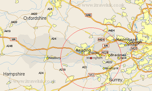
Berkshire Map Showing Location of Arborfield
Population: 1799
Area Size (ha): 152
Easting: 475353 Northing: 167386
Latitude: 51.4 Longitude: -0.92
 = Arborfield
Area Size (ha): 152
Easting: 475353 Northing: 167386
Latitude: 51.4 Longitude: -0.92
= Arborfield
This Arborfield map below is supplied by Google. Use the tools in the top left corner to zoom into street level or zoom out for a road map, you may also need to zoom in to see Arborfield on the map. Click and drag the map to move around. If the map fails to load try and refresh your browser or zoom in or out (+ or -).
Update - it seems Google no longer allow people to use their maps for free! This Arborfield map sometimes loads and sometimes gives a error. I am working on a solution.
Closest 30 Towns or Cities to Arborfield (Population over 500)
Shinfield 2.31km Barkham 2.97km Earley 3.88km Winnersh 3.93km Swallowfield 4.37km Woodley 6.02km Wokingham 6.07km Reading 6.86km Finchampstead 7.23km Sonning 7.51km Crowthorne 7.87km Mortimer 7.87km Stratfield Mortimer 7.87km Burghfield 8.09km Twyford 8.74km Tilehurst 9.82km Wargrave 9.89km Wagrave 9.89km Binfield 9.96km Waltham St. Lawrence 10.97km Waltham Saint Lawrence 10.97km Waltham St Lawrence 10.97km Sandhurst 10.98km Theale 11.04km Bracknell 11.71km Warfield 12.85km White Waltham 13.92km Pangbourne 14.81km Remenham 15km Winkfield 15.47km