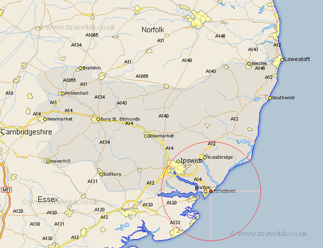
Suffolk Map Showing Location of Felixstowe
Population: 28311
Area Size (ha): 1121
District: Suffolk Coastal
Easting: 630096 Northing: 235151
Latitude: 51.97 Longitude: 1.35
 = Felixstowe
Area Size (ha): 1121
District: Suffolk Coastal
Easting: 630096 Northing: 235151
Latitude: 51.97 Longitude: 1.35
= Felixstowe
This Felixstowe map below is supplied by Google. Use the tools in the top left corner to zoom into street level or zoom out for a road map, you may also need to zoom in to see Felixstowe on the map. Click and drag the map to move around. If the map fails to load try and refresh your browser or zoom in or out (+ or -).
Update - it seems Google no longer allow people to use their maps for free! This Felixstowe map sometimes loads and sometimes gives a error. I am working on a solution.
Closest 30 Towns or Cities to Felixstowe (Population over 500)
Walton 2.06km Kirton 4.35km Kirkton 4.35km Shotley 6.85km Chelmondiston 9.32km Nacton 9.73km Bucklesham 10.09km Hollesley 10.88km Sutton 11.12km Martlesham Heath 12.02km Holbrook 12.69km Martlesham 13.41km Stutton 13.7km Melton 15km Woodbridge 15km Grundisburgh 16.32km Ufford 16.68km Rendlesham 17.29km Ipswich 18.04km Orford 18.04km Bentley 18.36km Wirnesham 18.7km Witnesham 18.7km Sprughton 19.46km Sproughton 19.46km Manningtree 19.5km Tunstall 19.75km Capel Saint Mary 19.75km Capel St. Mary 19.75km Capel St Mary 19.75km