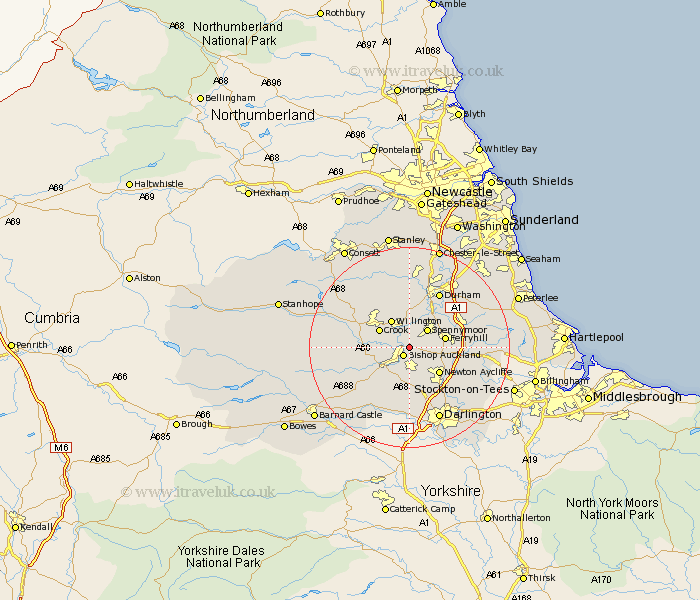
Durham Map Showing Location of Coundon
Population: 2501
Area Size (ha): 65
District: Wear Valley
Easting: 422571 Northing: 530248
Latitude: 54.67 Longitude: -1.65
 = Coundon
Area Size (ha): 65
District: Wear Valley
Easting: 422571 Northing: 530248
Latitude: 54.67 Longitude: -1.65
= Coundon
This Coundon map below is supplied by Google. Use the tools in the top left corner to zoom into street level or zoom out for a road map, you may also need to zoom in to see Coundon on the map. Click and drag the map to move around. If the map fails to load try and refresh your browser or zoom in or out (+ or -).
Update - it seems Google no longer allow people to use their maps for free! This Coundon map sometimes loads and sometimes gives a error. I am working on a solution.
Closest 30 Towns or Cities to Coundon (Population over 500)
Bishop Auckland 2.14km Shildon 3.71km Spennymoor 4.85km Willington 6.42km Crook 6.51km West Auckland 6.52km Ferryhill 6.69km High Etherley 6.69km Etherley 6.69km Newton Aycliffe 7.72km West Cornforth 9.34km Cornforth 9.34km Evenwood 9.34km Brandon 9.51km Bishop Middleham 10.87km Coxhoe 11.13km Cockfield 11.14km Bowburn 11.33km Durham 12.34km Ushaw Moor 12.97km Tow Law 13.02km Esh 13.36km Shincliffe 13.41km Gainford 14.04km Fishburn 14.05km Sedgefield 14.06km Staindrop 14.73km Witton Gilbert 14.86km Langley Park 14.86km Cornsay 14.97km