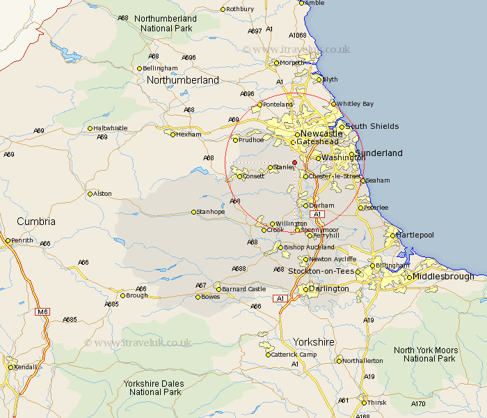
Durham Map Showing Location of Ouston
Population: 5840
Area Size (ha): 87
District: Chester-le-Street
Easting: 425000 Northing: 555000
Latitude: 54.89 Longitude: -1.61
 = Ouston
Area Size (ha): 87
District: Chester-le-Street
Easting: 425000 Northing: 555000
Latitude: 54.89 Longitude: -1.61
= Ouston
This Ouston map below is supplied by Google. Use the tools in the top left corner to zoom into street level or zoom out for a road map, you may also need to zoom in to see Ouston on the map. Click and drag the map to move around. If the map fails to load try and refresh your browser or zoom in or out (+ or -).
Update - it seems Google no longer allow people to use their maps for free! This Ouston map sometimes loads and sometimes gives a error. I am working on a solution.
Closest 30 Towns or Cities to Ouston (Population over 500)
Pelton 2.57km Birtley 2.86km Lamesley 3.15km Edmondsley 4.59km Chester-le-Street 5.16km Washington 6.1km Washington New Town 6.1km Gateshead-on-Tyne 6.24km Gateshead on Tyne 6.24km Gateshead 6.24km Stanley 6.56km Whickham 6.79km Burnopfield 6.92km Felling 8.01km Sacriston 8.05km Rowlands Gill 8.45km Annfield Plain 8.99km Witton Gilbert 10.01km Houghton le Spring 10.16km Blaydon 10.37km Hebburn 10.5km Hebburn-on-Tyne 10.5km Hebburn on Tyne 10.5km Langley Park 10.54km West Rainton 10.7km Lanchester 11.26km West Boldon 11.41km Boldon 11.41km Ushaw Moor 12.03km Leadgate 12.39km