Northumberland Map Showing Location of Kirkharle
District: Tynedale
Easting: 401063 Northing: 580262
Latitude: 55.12 Longitude: -1.98
 = Kirkharle
Easting: 401063 Northing: 580262
Latitude: 55.12 Longitude: -1.98
= Kirkharle
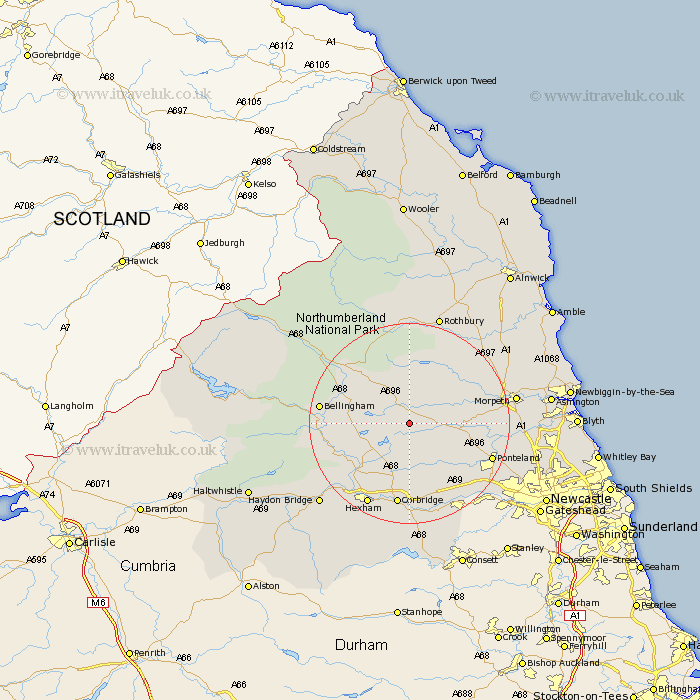
This Kirkharle map below is supplied by Google. Use the tools in the top left corner to zoom into street level or zoom out for a road map, you may also need to zoom in to see Kirkharle on the map. Click and drag the map to move around. If the map fails to load try and refresh your browser or zoom in or out (+ or -).
Update - it seems Google no longer allow people to use their maps for free! This Kirkharle map sometimes loads and sometimes gives a error. I am working on a solution.
Closest 30 Towns or Cities to Kirkharle (Population over 500)
Stamfordham 11.88km Chollerton 11.88km Challerton 11.88km Humshaugh 13.31km Sandhoe 15.43km Wark 15.86km Otterburn 16.1km Bellingham 16.32km Acomb 16.59km Ponteland 16.6km Corbridge 16.81km Warden 17.64km Newbrough 18.18km Ovingham 18.26km Hexham 18.26km Wylam 18.72km Longhorsley 18.9km Morpeth 19.86km Stannington 20.23km Prudhoe 20.39km Ridingmill 20.42km Riding 20.42km Hebron 20.45km Dinnington 20.48km Stocksfield 20.83km Hepscott 21.51km Woolsington 22.1km Longframlington 22.46km Rothbury 22.86km Pegswood 22.93km