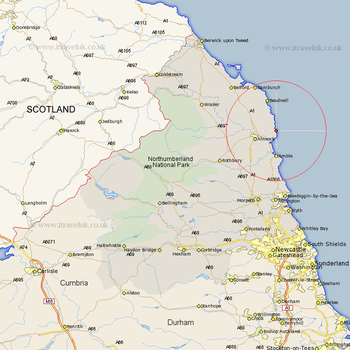
Northumberland Map Showing Location of Howick
District: Alnwick
Easting: 426363 Northing: 615571
Latitude: 55.43 Longitude: -1.58
 = Howick
Easting: 426363 Northing: 615571
Latitude: 55.43 Longitude: -1.58
= Howick
This Howick map below is supplied by Google. Use the tools in the top left corner to zoom into street level or zoom out for a road map, you may also need to zoom in to see Howick on the map. Click and drag the map to move around. If the map fails to load try and refresh your browser or zoom in or out (+ or -).
Update - it seems Google no longer allow people to use their maps for free! This Howick map sometimes loads and sometimes gives a error. I am working on a solution.
Closest 30 Towns or Cities to Howick (Population over 500)
Alnmouth 3.85km Embleton 5.94km Lesbury 5.95km Lisburg 5.95km Alnwick 8.24km Almwick 8.24km Warkworth 9.5km Shilbottle 9.73km Amble 11.12km Beadnell 13.35km North Sunderland 15.73km East Chevington 16.68km Swarland 17.59km East Thirston 17.84km Thirston 17.84km Felton 18.24km Longframlington 20.93km Rothbury 23.84km Ellington 24.11km Belford 24.32km Lynemouth 24.62km Longhorsley 25.08km Hebron 28.51km Wooler 28.51km Newbiggin-by-the-Sea 28.65km Newbiggin by the Sea 28.65km Pegswood 29.81km Ashington 29.96km Morpeth 30.31km Hepscott 31.78km