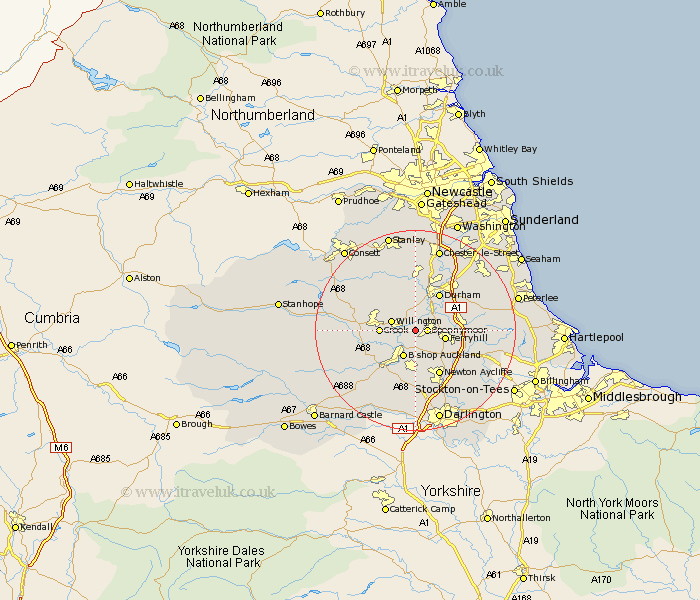
Durham Map Showing Location of Byers Green
District: Sedgefield
Easting: 423627 Northing: 533959
Latitude: 54.7 Longitude: -1.63
 = Byers Green
Easting: 423627 Northing: 533959
Latitude: 54.7 Longitude: -1.63
= Byers Green
This Byers Green map below is supplied by Google. Use the tools in the top left corner to zoom into street level or zoom out for a road map, you may also need to zoom in to see Byers Green on the map. Click and drag the map to move around. If the map fails to load try and refresh your browser or zoom in or out (+ or -).
Update - it seems Google no longer allow people to use their maps for free! This Byers Green map sometimes loads and sometimes gives a error. I am working on a solution.
Closest 30 Towns or Cities to Byers Green (Population over 500)
Spennymoor 2.14km Coundon 3.86km Willington 4.67km Brandon 5.66km Ferryhill 5.67km Bishop Auckland 5.96km Crook 6.43km Shildon 7.49km West Cornforth 7.5km Cornforth 7.5km Bowburn 8.36km Durham 8.56km Coxhoe 8.76km Ushaw Moor 9.32km High Etherley 9.34km Etherley 9.34km Shincliffe 9.81km West Auckland 9.82km Bishop Middleham 9.82km Esh 10.2km Newton Aycliffe 10.21km Witton Gilbert 11.12km Langley Park 11.32km Sherburn 12.16km Tow Law 12.34km Cornsay 12.61km Evenwood 12.62km Fishburn 12.99km Sacriston 13.02km Trimdon 13.92km