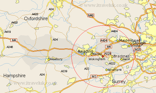
Berkshire Map Showing Location of Wokingham
Population: 37001
Area Size (ha): 1158
Easting: 481120 Northing: 169331
Latitude: 51.42 Longitude: -0.83
 = Wokingham
Area Size (ha): 1158
Easting: 481120 Northing: 169331
Latitude: 51.42 Longitude: -0.83
= Wokingham
This Wokingham map below is supplied by Google. Use the tools in the top left corner to zoom into street level or zoom out for a road map, you may also need to zoom in to see Wokingham on the map. Click and drag the map to move around. If the map fails to load try and refresh your browser or zoom in or out (+ or -).
Update - it seems Google no longer allow people to use their maps for free! This Wokingham map sometimes loads and sometimes gives a error. I am working on a solution.
Closest 30 Towns or Cities to Wokingham (Population over 500)
Winnersh 2.31km Binfield 3.93km Woodley 5.07km Barkham 5.08km Crowthorne 5.68km Twyford 5.68km Bracknell 5.78km Waltham St Lawrence 6.02km Waltham Saint Lawrence 6.02km Waltham St. Lawrence 6.02km Aberfield 6.07km Arborfield 6.07km Warfield 6.93km Earley 7.18km Sonning 7.23km Finchampstead 7.51km Wargrave 7.76km Wagrave 7.76km Shinfield 8.3km White Waltham 8.73km Winkfield 9.43km Sandhurst 9.55km Swallowfield 9.82km Reading 11.7km Ascot 11.71km Hurley 13.02km Bray 13.08km Sunninghill 13.25km Remenham 13.42km Stratfield Mortimer 13.88km