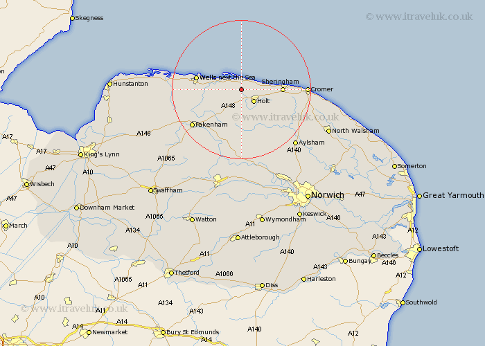
Norfolk Map Showing Location of Wiveton
Population: 158
District: North Norfolk
Easting: 603835 Northing: 341664
Latitude: 52.93 Longitude: 1.03
 = Wiveton
District: North Norfolk
Easting: 603835 Northing: 341664
Latitude: 52.93 Longitude: 1.03
= Wiveton
This Wiveton map below is supplied by Google. Use the tools in the top left corner to zoom into street level or zoom out for a road map, you may also need to zoom in to see Wiveton on the map. Click and drag the map to move around. If the map fails to load try and refresh your browser or zoom in or out (+ or -).
Update - it seems Google no longer allow people to use their maps for free! This Wiveton map sometimes loads and sometimes gives a error. I am working on a solution.
Closest 30 Towns or Cities to Wiveton (Population over 500)
Blakeney 4.33km Holt 5km Weybourne 7.82km Melton Constable 9.26km Mellon Constable 9.26km Briston 9.53km Sheringham 11.17km Walsingham 11.49km Little Walsingham 11.49km Wells on Sea 12.83km Wells-on-Sea 12.83km Wells next the Sea 12.83km Wells 12.83km Wells-next-the-Sea 12.83km Little Snoring 12.88km Hindolveston 13.01km Runton 14.52km West Runton 14.52km Corpusty 14.6km Ryburgh 15.15km Great Ryburgh 15.15km Foulsham 16.72km Foulham 16.72km Sculthorpe 17.24km Fakenham 17.43km Cromer 17.87km Erpingham 18.3km South Creake 18.73km Roughton 18.73km Colkirk 19.26km