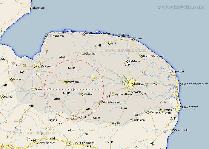
Norfolk Map Showing Location of South Pickenham
Population: 101
District: Breckland
Easting: 586217 Northing: 303836
Latitude: 52.6 Longitude: 0.75
 = South Pickenham
District: Breckland
Easting: 586217 Northing: 303836
Latitude: 52.6 Longitude: 0.75
= South Pickenham
This South Pickenham map below is supplied by Google. Use the tools in the top left corner to zoom into street level or zoom out for a road map, you may also need to zoom in to see South Pickenham on the map. Click and drag the map to move around. If the map fails to load try and refresh your browser or zoom in or out (+ or -).
Update - it seems Google no longer allow people to use their maps for free! This South Pickenham map sometimes loads and sometimes gives a error. I am working on a solution.
Closest 30 Towns or Cities to South Pickenham (Population over 500)
Ashill 3.38km Necton 6km Watton 6.74km Palgrave 7.5km Great Palgrave 7.5km Swaffham 7.91km Carbrooke 9.2km Carbooke 9.2km Griston 9.65km Shipdham 10.3km Northwold 11.56km Castle Acre 11.99km Mundford 13.01km Litcham 13.41km Rockland Saint Peter 13.49km Rockland St. Peter 13.49km Rockland 13.49km Rockland St Peter 13.49km Hockham 14.32km Narborough 14.57km Marham 14.6km East Dereham 15.45km Dereham 15.45km Yaxham 15.65km Hingham 15.87km Stoke Ferry 16.19km Mileham 16.28km Methwold 16.39km Great Ellingham 16.42km Beetley 17.17km