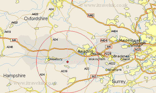
Berkshire Map Showing Location of Aldermaston
Population: 927
Easting: 459145 Northing: 165314
Latitude: 51.38 Longitude: -1.15
 = Aldermaston
Easting: 459145 Northing: 165314
Latitude: 51.38 Longitude: -1.15
= Aldermaston
This Aldermaston map below is supplied by Google. Use the tools in the top left corner to zoom into street level or zoom out for a road map, you may also need to zoom in to see Aldermaston on the map. Click and drag the map to move around. If the map fails to load try and refresh your browser or zoom in or out (+ or -).
Update - it seems Google no longer allow people to use their maps for free! This Aldermaston map sometimes loads and sometimes gives a error. I am working on a solution.
Closest 30 Towns or Cities to Aldermaston (Population over 500)
Brimpton 2.96km Beenham 3.71km Bradfield 5.68km Bucklebury 6.55km Cold Ash 7.87km Theale 8.02km Burghfield 8.3km Thatcham 8.31km Greenham 9.25km Mortimer 9.44km Stratfield Mortimer 9.44km Shaw 10.57km Tilehurst 10.98km Hermitage 10.98km Newbury 11.71km Reading 11.8km Pangbourne 12.04km Basildon 13.18km Chieveley 13.73km Shinfield 14km Speen 14km Swallowfield 14km Streatley 14.83km Earley 16.02km Arborfield 16.3km Aberfield 16.3km Compton 16.37km Barkham 18.51km Welford 18.86km East Ilsley 19.07km