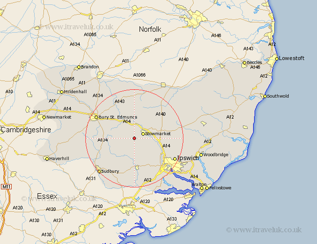
Suffolk Map Showing Location of Buxhall
Population: 426
District: Mid Suffolk
Easting: 600585 Northing: 256150
Latitude: 52.17 Longitude: 0.93
 = Buxhall
District: Mid Suffolk
Easting: 600585 Northing: 256150
Latitude: 52.17 Longitude: 0.93
= Buxhall
This Buxhall map below is supplied by Google. Use the tools in the top left corner to zoom into street level or zoom out for a road map, you may also need to zoom in to see Buxhall on the map. Click and drag the map to move around. If the map fails to load try and refresh your browser or zoom in or out (+ or -).
Update - it seems Google no longer allow people to use their maps for free! This Buxhall map sometimes loads and sometimes gives a error. I am working on a solution.
Closest 30 Towns or Cities to Buxhall (Population over 500)
Stowmarket 3.88km Rattlesden 3.88km Ringshall 5.04km Woolpit 6.01km Hitcham 6.01km Haughley 6.52km Great Bricett 6.52km Elmswell 7.49km Bildeston 7.5km Old Newton 7.95km Bradfield 9.82km Bradfield Saint George 9.82km Bradfield St. George 9.82km Bradfield St George 9.82km Norton 10.32km Cockfield 10.4km Somersham 10.88km Lavenham 11.74km Thurston 12.21km Bacton 12.48km Rushbrooke 12.65km Mendlesham 12.97km Badwell Ash 13.01km Hadleigh 13.03km Pakenham 13.04km Coddenham 13.05km Great Blakenham 13.58km Lawshall 13.77km Great Waldingfield 15.12km Waldingfield 15.12km