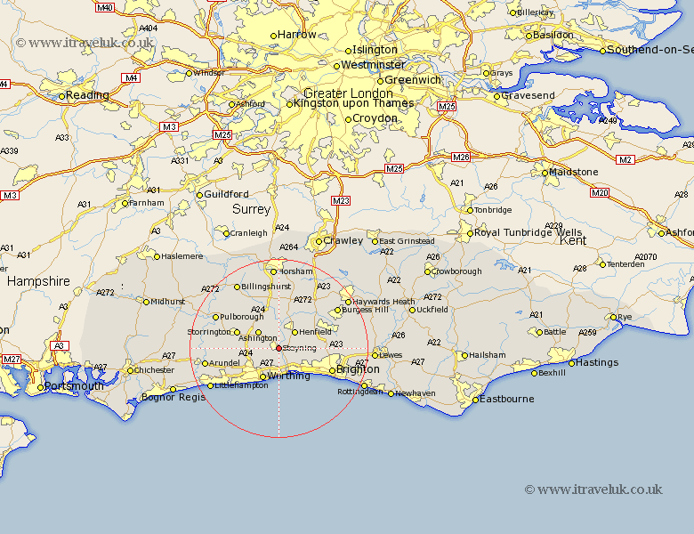
Sussex Map Showing Location of Bramber
Population: 757
District: Horsham
Easting: 518400 Northing: 110723
Latitude: 50.88 Longitude: -0.32
 = Bramber
District: Horsham
Easting: 518400 Northing: 110723
Latitude: 50.88 Longitude: -0.32
= Bramber
This Bramber map below is supplied by Google. Use the tools in the top left corner to zoom into street level or zoom out for a road map, you may also need to zoom in to see Bramber on the map. Click and drag the map to move around. If the map fails to load try and refresh your browser or zoom in or out (+ or -).
Update - it seems Google no longer allow people to use their maps for free! This Bramber map sometimes loads and sometimes gives a error. I am working on a solution.
Closest 30 Towns or Cities to Bramber (Population over 500)
Steyning 0km Henfield 5.1km Ashington 5.97km Washington 6.13km Findon 6.92km North Lancing 7.5km Lancing 7.5km Sompting 7.77km Worthing 7.87km Shoreham by Sea 8.07km New Shoreham 8.07km Shoreham 8.07km Shoreham-by-Sea 8.07km Thakeham 8.95km Southwick 8.95km Portslade 8.95km West Grinstead 9.35km Shipley 9.91km Storrington 10.12km West Chiltington 10.88km West Chillington 10.88km Albourne 10.88km Hove 10.89km Hurstpierpoint 11.16km Cowfold 11.66km Brighton 12.95km Nuthurst 13.03km Ferring 13.17km West Ferring 13.17km Keymer 13.38km