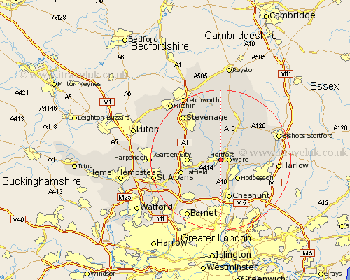
Hertfordshire Map Showing Location of Hertford
Population: 21509
Area Size (ha): 583
District: East Hertfordshire
Easting: 533296 Northing: 213079
Latitude: 51.8 Longitude: -0.07
 = Hertford
Area Size (ha): 583
District: East Hertfordshire
Easting: 533296 Northing: 213079
Latitude: 51.8 Longitude: -0.07
= Hertford
This Hertford map below is supplied by Google. Use the tools in the top left corner to zoom into street level or zoom out for a road map, you may also need to zoom in to see Hertford on the map. Click and drag the map to move around. If the map fails to load try and refresh your browser or zoom in or out (+ or -).
Update - it seems Google no longer allow people to use their maps for free! This Hertford map sometimes loads and sometimes gives a error. I am working on a solution.
Closest 30 Towns or Cities to Hertford (Population over 500)
Ware 2.29km Little Amwell 2.95km Hertingfordbury 2.95km Great Amwell 3.91km Stapleford 4.35km Thundridge 5.05km Harmer Green 5.62km Watton at Stone 6.01km Watton 6.01km Tewin 6.02km Stanstead Abbots 6.02km Widford 7.12km Hoddesdon 7.21km Little Munden 7.5km Bishops Hatfield 7.81km Datchworth 7.98km Essendon 7.99km Welwyn Garden City 9.17km Garden City 9.17km Benington 9.54km Bennington 9.54km Knebworth 9.76km Aston 10.89km Brookmans Park 10.93km Welwyn 10.96km Cheshunt 11.35km Standon 11.53km Hatfield 11.61km Cuffley 11.64km Much Hadham 11.71km